Specifications
1. Dual-frequency RTK GNSS.
2. 220-channel GPS+GLONASS+SBAS+GALILEO
3. Integrated UHF+GSM/GPRS+Bluetooth.
Professional 220 Channels Hi-target V90 GNSS RTK GPS Base and Rover Receiver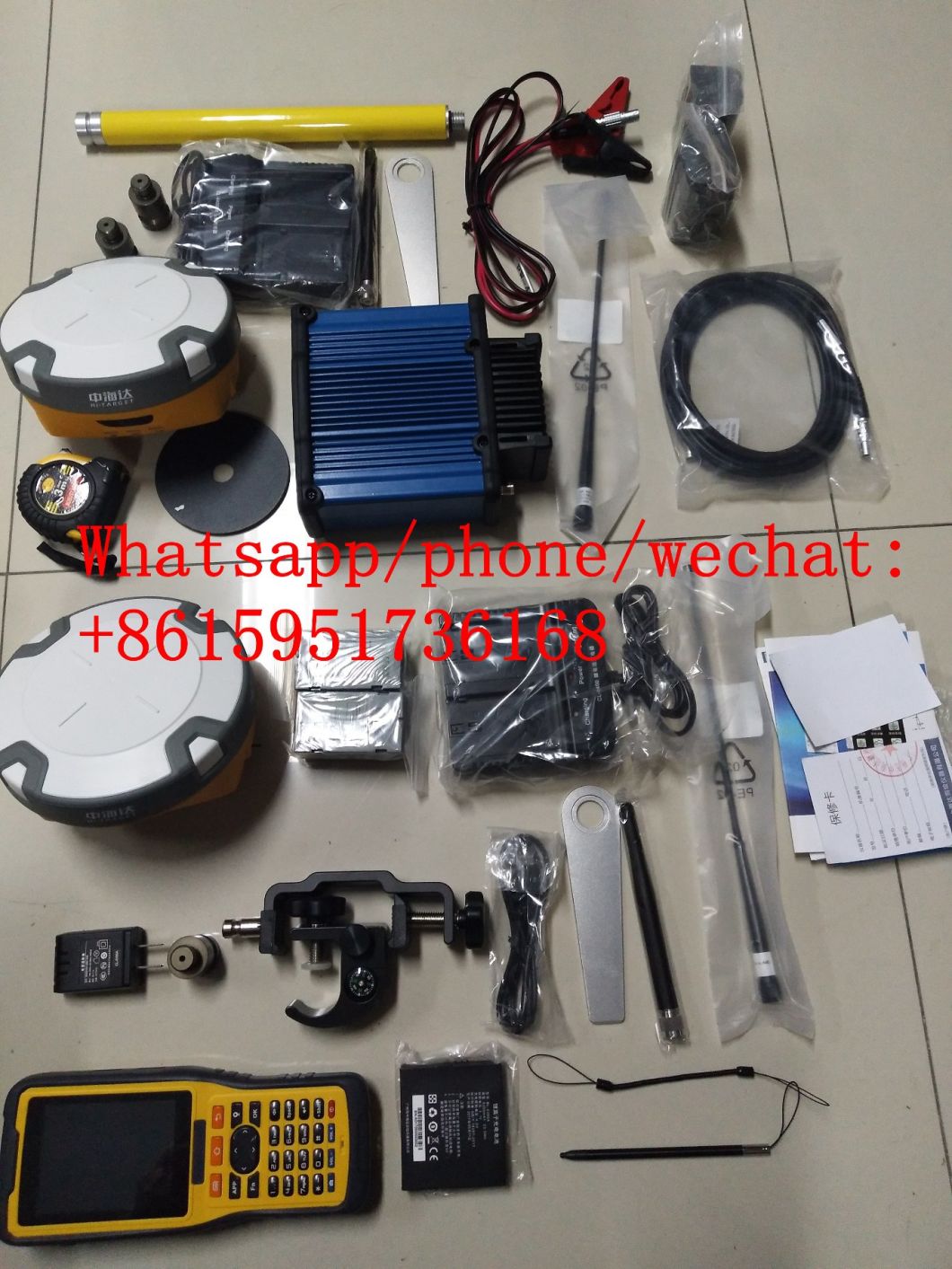
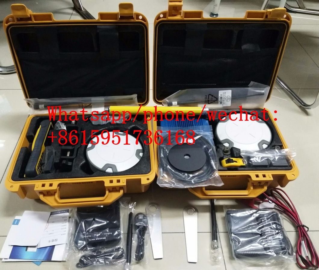
The Hi-Target V90 is a compact, high-performance GNSS receiver designed for precise surveying tasks. With an integrated Linux operating system, it supports multiple smart applications such as tilt surveying, electronic bubble calibration, NFC, and voice DIY. This makes the V90 an ideal solution for professionals in the surveying industry.
Â
Small and Lightweight
- Â Only weighs 950g.
- Â Measures Diameter 153mm x Height 83mm.
Multi-constellation Tracking
- 220 tracking channels
- Supports GPS, GLONASS, GALILEO, BDS, SBAS
- NGS approved full-band GNSS antenna
- Supports a wide range of satellite signals
- Large receiving area designed for multipath mitigation
- Air dielectric is light and stable
Smart Applications Â
- Â Supports electronic bubble calibration
- Offers tilt survey with a maximum tilt angle of 30 degrees.Â
- The internal NFC module makes Bluetooth communication quick and easy.
- Intelligent voice assistance guides field operations. Voice can be DIY.
-
Standard Rinex data and HI-TARGET raw data recorded simultaneously.
Optional Transceiver UHF Radio Â
- The transceiver UHF radio enables switchable working modes between base and rover.
- Three types of internal UHF radio provide different frequencies based on users requirements. The Pacific Crest TrimTalk© internal UHF radio is compatible with other radios.
Multi-network Connection
- Supports GPRS, GSM and WCDMA
- Supports WIFI
Powerful Battery
- Powered by high-capacity (5000mAh) Li-ion battery to ensure full day operation
Rugged Design
- IP67 dustproof and waterproof
- Able to survive a 3-meter natural fall onto concrete
-
iHand20 Field Controller
Default Configuration
Â
The iHand20 is designed for intelligent RTK with NFC sensor, a durable keyboard,ultra-long battery life and sensitive touchscreen, preinstalled free and intelligent Hi-Survey software. Hi-Survey software is the first high-precision survey software of Hi-Target running on the Android platform, supports tilt survey and electronic bubble, can perfectly cooperate with V90 Plus.
Â
Performance Specification of V90 | |||
Measurements |
220 tracking channels (Multi-constellation tracking) |
||
|
Satellite Signals Tracked Simultaneously |
GPS: L1 C/A, L2C, L2E, L5 |
||
GLONASS: L1C/A, L1P, L2C/A (GLONASS M only), L2P | |||
SBAS: L1 C/A, L5 | |||
Galileo: L1 BOC, E5A, E5B, E5AITBOC | |||
BDS: B1, B2 | |||
QZSS: L1 C/A, L1 SAIF, L2C, L5 | |||
NGS approved full-band GNSS antenna | |||
Positioning Performance |
Static and Fast Static GNSS surveying |
Horizontal: 2.5mm+0.5ppm RMS |
|
Vertical: 5mm+0.5ppm RMS | |||
|
Post processing Kinematic (PPK / Stop & Go) GNSS surveying  |
Horizontal: 10mm+1ppm RMS |
||
Vertical: 25mm+1ppm RMS | |||
Initialization time: typically 10 minutes for base while 5 minutes for rover | |||
Initialization reliability: typically > 99.9% | |||
|
Real Time Kinematic (RTK) Surveying  |
Single baseline |
Horizontal: 8mm+1ppm RMS |
|
Vertical: 15mm+1ppm RMS | |||
Network RTK |
Horizontal: 8mm+0.5ppm RMS |
||
Vertical: 15mm+0.5ppm RMS | |||
Initialization time: typically < 8 seconds | |||
Initialization reliability: typically > 99.9% | |||
|
Code differential GNSS positioning  |
Horizontal: 25mm+1ppm RMS |
||
Vertical: 50mm+1ppm RMS | |||
SBAS: 0.50m Horizontal, 0.85m Vertical | |||
Hardware |
Physical |
Dimensions(W × H):15.30cm×8.30cm (6.02 in.×3.27in.) Weight:0.95kgs (2.09lbs) without internal battery |
|
Operating:-40°C to +65°C (-40°F to +149°F) | |||
Storage temperature: -40°C to +75°C (-40°F to +167°F) | |||
Humidity:100%, considering | |||
Water/dust proof: IP67 dust proof, protected from temporary immersion to depth of 1m (3.28ft) | |||
Shock and Vibration.Designed to survive a 3m(9.84ft) nature fall onto concrete. | |||
Battery: rechargeable, removable 7.4V, 5000mAh /block lithium battery in internal battery compartment | |||
Internal battery life: Static 12 hours, RTK rover (UHF/ GPRS / 3G) 8-10hours, RTK base 8 hours | |||
Electrical |
Power 6V to 28V DC external power input |
||
Power consumption< 3.5W | |||
|
Automatic switching between internal power and external power | |||
|
Battery: rechargeable, removable 7.4V, 5000mAh /block lithium battery in internal battery compartment | |||
Internal battery life: Static 12 hours, RTK rover (UHF/ GPRS / 3G) 8-10hours, RTK base 8 hours | |||
Power 6V to 28V DC external power input | |||
Power consumption< 3.5W | |||
I/O interface |
1×Bluetooth, NFC |
||
1×standard USB2.0 port | |||
2×RS232 serial port | |||
2×DC power input(8-pin & 5-pin) | |||
1×Micro SD card port for GSM or CDMA | |||
Tilt survey system & electronic bubble |
|||
Communication, system and data storage |
Network Communication |
Fully integrated, fully sealed internal WCDMA, compatible with GPRS,GSM, WIFI frequency is 2.4G, supports 802.11b/g/n protocol |
|
|
Fully integrated, fully sealed internal WCDMA, compatible with GPRS,GSM, WIFI frequency is 2.4G, supports 802.11b/g/n protocol | |||
HI-TRAGERT internal UHF radio (standard) |
Frequency: 450~470MHz with 116 channels |
||
Transmitting power:0.5W, 1W, 2W adjustable | |||
Transmitting speed: 9.6Kbps,19.2Kbps | |||
Working range: 3-5km typical, 8-10km optimal | |||
|
Pacific Crest XDL Micro internal UHF radio |
Frequency: 403~4 Jiangsu Manrui New Materials Co., Ltd , https://www.manruiwire.com | ||